


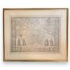
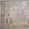
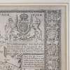
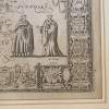
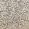
Framed Cambridgeshire Map by John Speed
A framed appealing uncolored engraved map of Cambridge, stretching the border with Huntingdonshire in the west to Suffolk in the east.
view more by this dealerDimensions:
W-69 D-2 H-58 (cm)
Item Reference:
96753-1599-2Tip! This item's Ref-Code breaks down thus...
Item Ref Code: 96753-1599-2
Item No. 96753 - Dealer No. 1599 - Building No. 2
Share this product:
Description
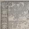
A framed appealing uncolored engraved map of Cambridge, stretching the border with Huntingdonshire in the west to Suffolk in the east. There is an expanded plan of the historic university town of Cambridge in the North West. The map was part of the earliest English attempt at producing an atlas on a grand scale as part of 'The Theatre of the Empire of Great Britain', the work for which Speed is best known. circa 1676
Specifications
- Item Reference
- 96753-1599-2
- Dimensions
- Height: 58 cm
- Width: 69 cm
- Depth: 2 cm
- Period
- 18th Century & Earlier
- Material
- Paper
- Country of Origin
- England
- Era
- Early Antiques
- Condition
- Good Condition, Some Age Wear.
Delivery
- Free Collection from Hemswell, North Lincolnshire (we can store free of charge for four weeks)
- UK Post for £15, this applies to smaller items that we can box up and simply post to you.
- UK Courier for £30, this applies to larger items that can be boxed up and collected by a standard courier delivery company.
- UK Van Delivery by Hand, this applies to furniture, large items or delicate items. This is undertaken by ourselves or by a fully insured van delivery company that is personally known to us. Prices dependant on your location and size/amount of items purchased.
We are able to deliver any item to anywhere in the World, and so for any item/location, we are able to obtain quotes for delivery/shipping.


